Projects
-
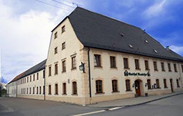
Renovation Gasthof Rauscher
2350 m2 gross footprint • approx. 1890 m² facade surface • requirements for conservation of ancient monuments • 211 created Scans • Execution time 01-02/2013 more... -
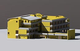
Modernisation of Hauptschule Peissenberg
Modernisation and extension • 6.165 m² captured ground-plan area on 5 floors • approx. 2.650 m² facade surface • 326 Scans indoor and outdoor • Split-Level • Execution time 09–10/2010 more... -
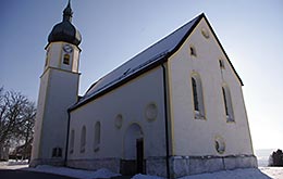
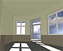
Church St. Matthäus, Restoration
Restoration with requirements for conservation of ancient monuments • 53 scans inside and outside • Execution time: 03–06/2012 more...
Laser scanning on buildings: Planning reliability by accurate data
The basis for planned modification, extension or restoration work on buildings are accurate as-built plans. What is not generally known: This is often the most difficult task. Either this documentation is not available at all or it is out-dated and useless because past modification work has not been documented and thus it is not corresponding to the actual condition.
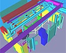
For construction projects planning reliability is especially necessary. To fulfil this requirement the as-built documentation by 3D laser scanning is an efficient possibility. With 3D laser scanners very accurate and comprehensive point clouds of the capturing area are created and thus also complex structures can be captured in a very short time.
The accuracy of the measurement with 3D laser scanners is so high that the compliance to tolerances in construction are far below. But „too exact“ won't hurt.
We are experts in this sector. With our expertise in the sector of geodesy we guarantee perfect surveying work – also if it's getting complicated: The location and altitude interface to the coordinate system of the client or superior coordinate systems as well as the creation of tensionless fixed-point fields in buildings across all floors – all this is the basis for the compliance of tolerances of the created point clouds. These tolerances are in millimetre range – however across the complete building.
No matter if from the geo-referenced individual scan or from the combined point cloud: We are creating data for many different applications.What are your requirements?
No matter if from the geo-referenced individual scan or from the combined point cloud: We are creating data for many different applications.What are your requirements?
more...