As- built documentation with 3D laser scanning
As- built documentation with 3D laser scanning
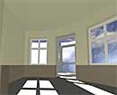
The as-built documentation of factory buildings and production plants with our 3D laser scanners is the basis for the creation of simulation and planning data for the Digital Factory. It results in point clouds with high definition, which reflects the reality of the according capturing area. The high-precision data can now be prepared for different applications. Data of BKR are used for the Digital Factory in various fields.
Various possible formats to be provided
3D point clouds can be provided in different formats, e.g. for processing them with the customer’s own laser scanning special software for modelling or visualisation. Interactive views and optical analysis of current plans and constructions help to make precise decisions. In combination with simulation calculations and design data, complex variants can be comprehensively illustrated and analysed.
3D Models
3D models from the different departments are integrated into the data basis of the Digital Factory and are used together. Overall considerations and tasks – of utmost importance for realistic presentation - are deriving from this basis. For our models we are using the complete capturing data from our 3D laser scanners. This is as well a benefit for various applications and target markets, such as architecture, building services, steel industry and factories.
back...
The as-built documentation of factory buildings and production plants with our 3D laser scanners is the basis for the creation of simulation and planning data for the Digital Factory. It results in point clouds with high definition, which reflects the reality of the according capturing area. The high-precision data can now be prepared for different applications. Data of BKR are used for the Digital Factory in various fields.
Various possible formats to be provided
3D point clouds can be provided in different formats, e.g. for processing them with the customer’s own laser scanning special software for modelling or visualisation. Interactive views and optical analysis of current plans and constructions help to make precise decisions. In combination with simulation calculations and design data, complex variants can be comprehensively illustrated and analysed.
- Overall point cloud as LFM server database, e.g. as basis for external modelling or planning
- Leica Cyclone projects for the usage with different applications for creating intelligent 3D models, like AutoCad or MicroStation with its additional features
- Registered individual scans for visualisation of the 3D point cloud, e.g. with NavisWorks
- ASCII data with RGB values for visualisation in special software, e.g. visualisation of the 3D point cloud with realicon – 4D communication
- Ortho pictures – sections or views of the point cloud as grid data which is geo-referenced in correct positional arrangement to CAD drawings – can provide a fast overview of the situation in the according area.
3D Models
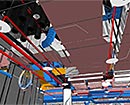
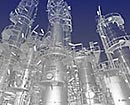
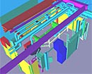
3D models from the different departments are integrated into the data basis of the Digital Factory and are used together. Overall considerations and tasks – of utmost importance for realistic presentation - are deriving from this basis. For our models we are using the complete capturing data from our 3D laser scanners. This is as well a benefit for various applications and target markets, such as architecture, building services, steel industry and factories.
- Architectural models: On basis of MicroStation we are realising e.g. 3D models with Speedikon Architektur. But we can also offer the construction of volume models in MicroStation or AutoCad. Our virtual 3D buildings models are used for Facility Management. They form the shell of the Digital Factory and are basis for allover construction tasks.
- Technical Building Services e.g. 3D models of the building equipment are created with high-performance programs like TriCad.
- Steel construction models Especially in production halls we are creating digial models, e.g. of the existing steel construction of supporting structures or stages with its entries.
- Interfering edge models: They picture the internals of machines or plant components, for which no exact modelling is necessary. The main task in this case is to document existing free space for reworks or new internals.
- Plan models can be 3D models of conveyor systems or assembly lines, which are created with appropriate software from the point cloud.
- Generating of 2D data from 3D models
On basis of the model data we can interactively create the 2D data – according to the requirements – for floor plans, sections and views as well as for different overview plans. - Visualisation
For the 3D visualisation we use amongst others programs like NavisWorks. With NavisWorks the visualisation and analysis of 3D models from different data sources with high functionality is possible. Thus CAD models can be visualised and animated together with the data from 3D laser scanning. Navis Works is an important tool for the transfer of project data, for the interactive visualisation and real-time editing of large and complexe 3D models incl. measuring, commenting, linking and comparing. Creation of views, sections and animations: NaviWorks is compatible to the well-known 3D design formats like MicroStation, AutoCad, PDMS and PDS.
back...